Trip Report: Sofa - Vimy Traverse (FIXED)
(Sorry about the pictures not loading. This should fix it.) First off, Chris Goble has posted a description here. I thought I would do a write-up with some pictures and gps stuff (disclaimer - the way points were done with my phone gps and the route was pieced together from the way points and memory. All lines on the pictures are approximations and were drawn by hand. Everything is subject to inaccuracies and should be taken with a grain of salt).


I will try to use mostly pictures to reference the route. I headed up the right ridge. I have pictures at point 1 and then point 2.
()
Point 1

Point 2

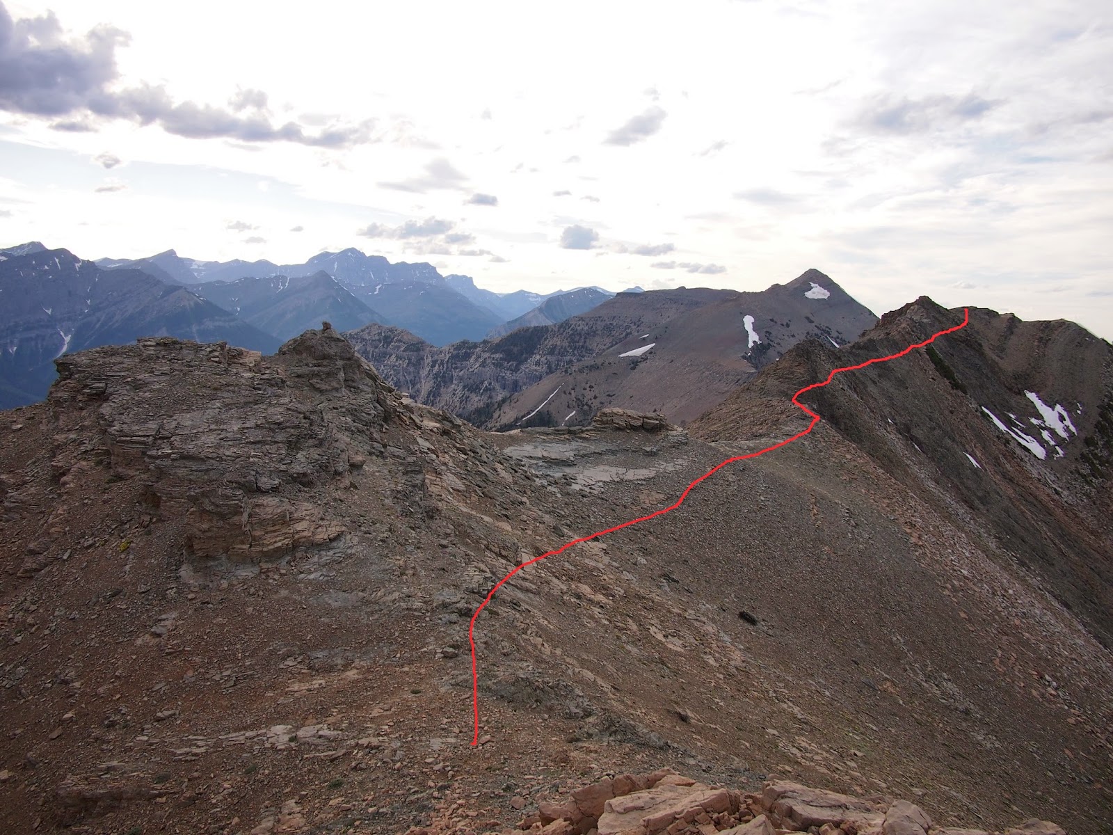
The scrambling after point 2 isn't bad, you can easily stand and get your bearings. After a short while you are back to scree. You can then summit this point which has a survey marker. After that, it's a walk to the summit of Sofa.

The summit of Sofa had only a Cairn. From the summit, you head West down the "Sheep Shearer's Ridge" that is exposed and full of cool blocks of rock.


At the end of the ridge, you work your way up through the broken cliff band. You basically traverse till you find what you like.

The last cliff has a few options. I came up on the right side of the only tree on the upper cliff. It's about halfway up the steep stuff.

One you reach the top, you traverse along the peak. I didn't think it was worth the time. As you come around, there is a predominant ledge that leads to what I would call ledge steps.

This is the view from those steps. Carefully traverse and step down to a plateau. From here I traversed on the left side of these columns with the yellow lichen bands.
.jpg)
At one point, I traversed upwards, switching to the inside/right side. Here is the view from part of the way up. I wish I had taken a picture of what it looked like. Basically it looked easier than the left at this point. Just a reminder. If I figured I could go back down it, I didn't go up it.

After a short time on the right side, I peaked the ridge and started traversing the unknown peak on the left side again. I went all the way around first and then doubled back up to the peak. As you can see from below, it was an easy climb up. A summit Cairn was at the top.

The next peak was much the same. I traversed to the left, circling around to the next ridge and doubling back on the peak. The ridge was high up, so there wasn't much vertical left to the peak. This peak (Arras Peak) had a log book that you can enter your name into.
As you continue on, the ridge turns to the right. I traversed on the right side, aiming towards this lone tree you can see in the next shot.

A short distance after the tree, the ridge plateau's and rolls over the top. You continue on easy terrain till a row of trees forms and the ridge will drop off to the left.

This is the last ridge that drops and then rises to Vimy. Right where the snow patch ends on the way up the ridge is where I started my sideways traverse. I started at a shrub right above the snowpatch.

This is that shrub.

Eventually as you traverse, there is a break in the upper cliff band and I traversed closer along the top. You can see that point here.

Finally, the summit looked as you see it, with these rather large blocks.

Finally, you descend onto an easy to find trail and exit. I exited at the Chief Mountain Road, making for about a 30 km trip (I decided to bivy and make it an easier two day trip.)
It was a pretty surreal experience and I enjoyed the time alone on this one. For anyone else thinking of doing it, I've included the Waypoints and Route in gpx format. To look at it on Google Earth, here is the KML file, this file is slighlty different to match up with Google. You can access all my files linked to this hike here and all my pictures here. Enjoy!
Labels: Scrambling, scrambling route descriptions
posted by Grand Master I @ 7/06/2014 10:49:00 PM
3 Comments
![]()


3 Comments:
looks like an awesome trip I will definitely be trying soon. I would like to post some of my trip reports from waterton and the surrounding area but don't know how to post to this site? help?
The best place for trip reports is actually the club tread community http://www.clubtread.com/sforum/default.asp
They're a pretty active group. This blog is mostly a static repository now. I'll write up new technical routes, but even those are now posted few and far between…
Chris
These views are so beautiful and amazing, love to read more amazing stories regarding to adventurous travel.
luton Meet And Greet
Post a Comment
Subscribe to Post Comments [Atom]
<< Home